Overview
FFMVic’s role is to reduce bushfire risk to communities and the environment.
Following the emergency response phase, FFMVic are now carrying out targeted works across areas affected by severe storms during the winter and spring of 2021, and February 2024, by removing storm debris to reduce fire risk and rehabilitate the forest.
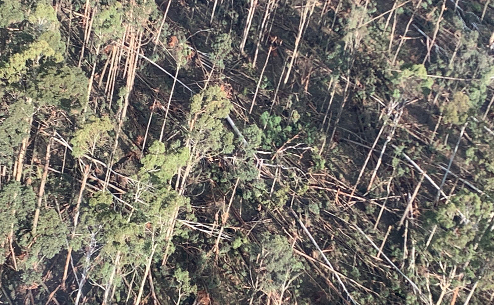
This work is necessary as the storms resulted in hazardous trees and debris across about 2,000 hectares of public land that has increased bushfire risk and blocked safe access for firefighters.
In December 2024, a fire started in Mirboo North, Gippsland. It took first response firefighters three times longer than usual to construct control lines around the fire due to fallen debris from the February 2024 storm.
Removing some of this debris allows us to keep our communities safe.
These are not commercial timber harvesting operations; trees are only removed where they create a safety or fire risk.
Where safe to do so, we leave fallen trees for wildlife habitat.
Because each part of the forest is different, we use the most suitable treatment options at each site to manage safety and bushfire risk.
FFMVic assesses and surveys each area and plans works to minimise impacts on flora and fauna. The program follows a rigorous planning and approvals process to meet responsibilities under Commonwealth and Victorian environmental legislation. Removed debris goes to the best use. This can include:
- free domestic firewood
- community projects, or
- supporting local businesses.
What we have done so far
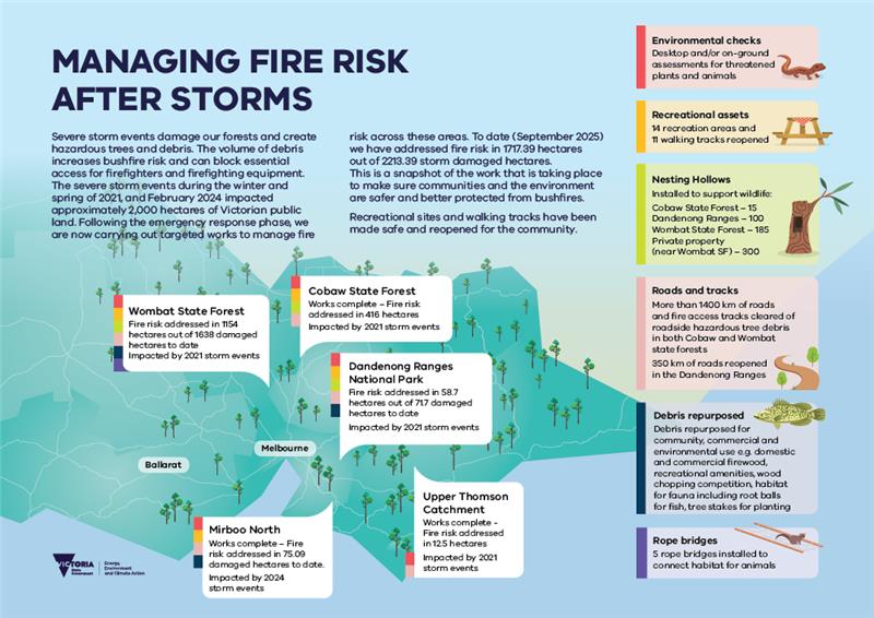
Works are complete in:
- Cobaw State Forest
- Upper Thomson Catchment
- Mirboo North
Find out what works are happening near you:
To see work at site level, click on the interactive map below.
The pins on the map show you:
- roadside works in purple - horizontal hatching
- broadacre works in orange - vertical hatching (broadacre means works in areas beyond roads and tracks).
If you zoom in, you will see the hatched area and the boundary of each treatment site.
Clicking on a pin or a hatched area, will provide you with information about a site, including:
- a unique site number
- the name of the location of where works are taking place (note that the name usually relating to a road or track)
- which organisation they are being done for, usually DEECA and sometimes on behalf of a land manager
- a description of the status of the works, with an estimated start or finish date for the works (if available).
Please note: The hatched area on the map is the total site area. The treatment area that debris is being removed from is generally only part of the site area.
In State forests, Public Safety Zones will be put in place before works begin on any site. This restricts access to make sure everyone is safe while heavy machinery is in the area. It is an offence to enter a Public Safety Zone. For works in National Parks, Parks Victoria will manage closures.
What is a hazardous tree?
Falling trees and branches are a significant safety risk to firefighters, staff and the community travelling through or working in affected areas.
A hazardous tree typically has one or more of the following characteristics:
- Dead or decaying tree or major branches
- suspected loose or broken branches
- significant lean with recent cause or indicators of failure
- evidence of lengthwise cracking
- evidence of roots lifting, or an undercut or disturbed root system
- other indicators of serious weakness based on local knowledge and conditions.
Environmental values
When FFMVic needs to remove debris to reduce bushfire risk, we look to minimise impact on environmental and other values.
We take care to plan a program that meets our responsibilities to manage the risk of bushfire to communities and the environment.
Because each part of the forest is different, we will consider the best option for each site.
We carry out planning for individual sites. This includes:
- defining the areas that need to be treated for fire risk within each site
- talking to stakeholders
- undertaking desktop assessments and field checks for biodiversity values
- defining exclusion zones or buffers to protect values.
Buffers are areas where works might be excluded or modified to protect a particular value, for example:
- a waterway
- a threatened plant
- habitat for a threatened animal.
Protections can include:
- Excluding sensitive areas from works
- tree root protections
- minimising soil disturbance
- treating invasive weeds
- identifying habitat trees of possum species
- limiting removal of standing trees.
We then decide the most suitable treatment option — or options — at each site. These include:
- Removing all debris, for example on tracks and roads
- removing some debris, but leaving some debris for habitat
- putting a low-intensity planned burn through the site
- removing hazards to create safe access for firefighters
- planting tube stock or sowing seed.
Standing trees will only be removed where they have been assessed as hazardous and are a risk to safety.
Where appropriate, fallen trees are left for wildlife habitat. They are an important component of a healthy forest.
We aim to retain trees with hollows, which are commonly used as habitat for a range of species.
Bushfire risk
We will always have bushfires in Victoria - it is one of the most bushfire prone regions in the world.
FFMVic's role is to protect life, property and the environment from bushfires on public land.
We remove storm debris where it is a fire risk, and prioritise locations based on risk levels.
Bushfire risk is posed by drying finer debris as well as fallen trees and branches. Large volumes of debris can make it harder and unsafe for firefighters and the public to access areas.
We treat finer debris as a priority through planned burns and other fuel management activities. We remove the large logs created by fallen trees, as these can generate significant radiant heat and block firefighter access during bushfires.
To effectively manage our bushfire risk, we employ several strategies:
- take every opportunity to manage our bushfire risk all year round
- use a range of different tools and methods to get it done effectively with less risk.
We reduce bushfire risk by:
- undertaking planned burning and mechanical fuel management works such as clearing, mowing, and slashing
- constructing and maintaining
- fuel breaks and maintaining fire infrastructure, such as fire dams.
Our year-round strategic fuel management approach gives our firefighters a better chance of controlling fires when they do occur – reducing impacts on people, property and the environment.
Page last updated: 25/06/25