Program background
Strengthening and expanding Victoria’s network of strategic fuel breaks is one of the key actions that form DEECA’s Bushfire Management Strategy , designed to reduce impacts of more frequent, intense and damaging bushfires under a changing climate.
Fuel breaks are a critical bushfire management tool that assist in protecting communities, catchments and the environment by limiting the size, spread, behaviour and impact of bushfires. They do this by making it easier, faster and safer for firefighters to suppress fires.
As a last resort, they can also assist in reducing the intensity of direct fire on houses and other buildings.
The Victorian Government invested $35.8 million in the 2020-21 Budget to build and upgrade 1447 kilometres of fuel breaks over 3 years. This program delivered this work in three tranches and exceeded its target by delivering 1,489 kilometres by 30 June 2023.
This program, plus additional investment in 2023-24, delivered a total of 1548 kilometres of new and upgraded fuel breaks across the state.
Why is the Victorian Government investing in strategic fuel breaks?
The Victorian Auditor-General's Office (VAGO) audit into Reducing Bushfire Risk and the Inspector General for Emergency Management’s (IGEM) Inquiry into the 2019-20 Victorian Fire Season highlighted the strength of Victoria’s approach to managing bushfires and bushfire risk on public land. They recommended that Victoria both expand this approach and integrate it on private land to respond to the changing fire conditions.
The investment will support Forest Fire Management Victoria (FFMVic) to lead this response, strengthening and expanding the network of fuel breaks across Victoria to respond to the immediate challenges caused by climate change and better prepare Victoria for future fires.
What are strategic fuel breaks?
Strategic fuel breaks are a strip of land where vegetation has been permanently modified to reduce the rate of spread and intensity of fire for the direct protection of assets and/or to assist fire control.
Fuel breaks form part of the landscape infrastructure necessary to safeguard communities by providing safe access and egress for firefighters to undertake fuel management and fire suppression activities.
Firefighters need to be able to move safely and seamlessly to carry out backburning operations to contain the spread of fires before they reach communities and assets.
Depending on their purpose, strategic fuel breaks are fuel reduced areas up to 40 m wide that, once established, resemble open grassy wood or heath lands. They involve the permanent reduction of bushy vegetation through mulching and slashing, and the removal of hazardous trees and impediments to maintenance such as stumps, logs and branches.
What benefits will this deliver?
The bushfire management measures will:
- provide increased protection to communities, environment and assets
- improve access and egress of firefighting resources contributing towards suppression effectiveness and efficiency
- enable firefighters to move seamlessly to undertake backburning operations to contain the spread of fires before they reach communities and assets.
- support jobs and economic recovery in regional areas
- respond to more frequent, intense and damaging bushfires under a rapidly changing climate
- reduce costs and damages as assessed in previous large-scale bushfire events.
What is the difference between a landscape protection break and an asset protection break?
The Fuel Break program uses 2 types of protection breaks.
Landscape protection breaks
Located in the forest to effectively support the containment of bushfires through backburning as part of suppressing an active bushfire in more remote landscapes and helping to reduce the fire to the smallest possible size. These breaks provide a platform for fighting fires in the forest, manage the risk posed by hazardous trees and may also reduce fire impacts on nearby communities.
Before landscape protection break

After landscape protection break

Landscape protection break diagram key:
 Track-Road
 Verge
Verge Maintained ground veg
 Untreated ground veg
 Hazardous tree
- Diagram not to scale. Hadazardous trees beyond the break area that do not pose a risk to firefighter safety will be retained.
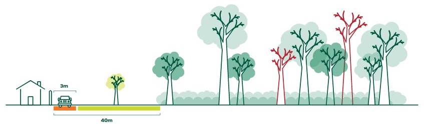
Asset protection breaks
Designed to provide safe access for firefighters to conduct activities to defend communities and assets from the direct impacts of fire. These breaks are generally located adjacent to townships and assets.
- Simple (constructed track)
- Hazardous trees removed
- Up to 50–70% canopy and stumps removed
- 40m modified zone
- Treated annually
Unmanaged edge

Asset protection break (side view)
Asset protection break (top view)
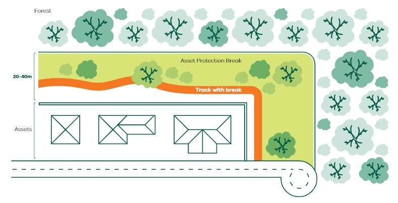
Diagram key:
- Track or slashed line
- Treated ground veg
- Untreated ground veg
- Hazardous tree
 Retained trees
What criteria are used to choose a location for a strategic fuel break?
The strategic fuel break locations undergo a process of analysis, data validation and consultation before being prioritised on the basis of their value in assisting firefighters to reduce the spread of future bushfires and feasibility.
These fuel breaks will be prioritised against a criterion to ensure the selected locations provide the greatest risk reduction to landscapes and assets, whilst considering impacts on species diversity, cultural heritage and tenure.
The location of strategic fuels breaks designed to protect assets is strongly influenced by the proximity of fuels and likely paths for fire that might impact values and assets. The preferred location of these breaks is often evident, and is informed by sophisticated bushfire modelling.
Strategic fuel breaks provide a platform for fighting fires in the forest and may also reduce the impact of fire on nearby communities. Understanding where fires start and spread and where firefighters will need to undertake backburning operations helps to determine the location of breaks. The design of these breaks is also influenced by fire control expertise.
Page last updated: 13/07/26