Fire summary
- Location: 27 km west of Walwa, north‑east Victoria
- Ignition: 5 January 2026, during a severe heatwave
- Containment: 2 February 2026
- Area burned: More than 120,000 hectares—roughly the size of Greater Melbourne’s urban footprint
- Terrain: Steep, rocky, heavily forested, with limited access
Assets impacted: Private property, communications infrastructure on Mt Lawson, pine plantations, recreation sites, registered cultural and historic heritage sites.
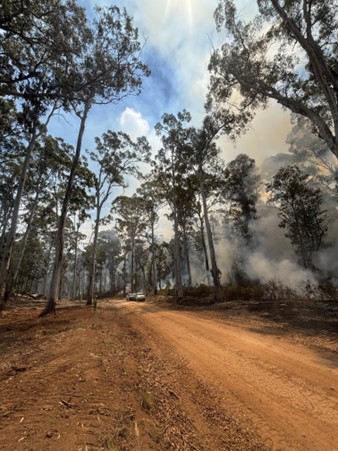
Fire behaviour
- Escalated rapidly, with crown fire development,
- Spotting up to 300 metres ahead and difficult access for ground crews
- Strong winds and very dry fuels contributed to a fast‑moving bushfire
Resources
- FFMVic and CFA ground crews
- Tankers, slip‑ons and heavy machinery (dozers, graders, trucks)
- Firebombing aircraft
- Drones for aerial monitoring and hotspot detection.
Because of the fuel management that’s been done here over time, including between the extreme fire days, firefighters were able to get in safely, slow the fire down and actually work on it."
Overview
 The Walwa fire burned through some of Victoria’s most iconic environments from the rugged peaks of Mount Lawson State Park to the pine plantation country of Guys Forest and Shelley and the river flats near Bungil known for camping, fishing and summer picnics.
Forest Fire Management Victoria (FFMVic) led the work across public land near Gibb Range Road, supported by the Country Fire Authority (CFA) and partner agencies. Part of the containment strategy combined strategic fuel breaks, recent planned burns and on‑ground backburning operations to strengthen control lines and improve firefighter access during the January 2026 Walwa–River Road bushfire.
The Gibb Road Strategic Fuel Break is part of Victoria’s statewide network of more than 1,500 km of pre‑planned control lines designed to create safer access for firefighters and allow for rapid implementation of backburning strategies. Backburning is used during a bushfire where firefighters burn off control lines to remove fuels between a control line and an active fire edge.
Fuel management in Walwa
Fuel break
The Gibb Road Strategic Fuel Break is designed to permanently reduce vegetation along a key ridge‑line corridor providing:
- better access for crews
- a safer platform for ignition and holding operations
- reduced fire intensity and flame heights
- a defensible line for backburning
- protection for nearby communities and infrastructure.
Constructed and maintained before the 2025/26 fire season, the fuel break had already undergone hazardous tree removal and routine maintenance, ensuring it took little effort to make fully operational when the Walwa fire reached Gibb Range Road. Having this break ready gave firefighters a significant advantage, allowing them to safely complete around 40 km of backburning during days and nights with milder conditions. If this work had not been done previously, construction of the break during the firefight would have taken several days. During bushfire response this time is often the difference between containing a fire or not.
Containing a fire before the next increase in fire danger conditions is critical to prevent further spread and impact on communities.
During the 2026 Walwa fire, crews operating along the Gibb Range Road Fuel Break were able to start backburning strategies without spending several days building the break first. They safely applied around 15,000 hectares of planned fire off that break. Without that fuel break already in place, that fire could have grown from approximately 120,000 hectares to over 300,000 hectares. In this instance, not containing the bushfire would have put communities such as Berringama and Corryong at risk.
Landscape condition before and after treatment
Before treatment, the forest surrounding Gibb Range Road contained dense undergrowth, bark, leaf litter and hazardous trees. Many areas had steep slopes and limited access making suppression difficult.
After treatment, the fuel break provided:
- a wide, open corridor
- safe working space for plant and vehicles
- reduced surface and elevated fuels
- a reliable control line during backburning.
Planned burns
Recent planned burns in the surrounding landscape including along Morgans Fireline and in Cravensville played an important role in containing the Walwa fire. These burns had reduced fuel loads in strategic blocks, meaning firefighters could safely tie their backburning operations into areas with lighter fuels and more predictable fire behaviour.
This combination of previously burned areas, the Gibb Road strategic break and active backburning created a layered defence that helped slow the fire’s spread and strengthen containment lines. These activities also decreased the intensity of the fire, reducing the severity of damage to the environment and aiding recovery of these ecosystems.
Outcomes
When the fire reached the treated areas, flame heights decreased, spread slowed and crews were able to work safely from the strategic break and planned burn edges.
Fuel management treatments made a measurable difference, providing:
- reduced fire intensity and severity of its impact
- halted or slowed fire spread
- increased containment success
- safer operational conditions
- more stable control lines
- a reliable platform for backburning.
As incident leaders noted, using a mix of strategic fuel breaks, previous planned burns and backburning gave firefighters a clear advantage during a highly challenging fire event.
Page last updated: 08/07/26